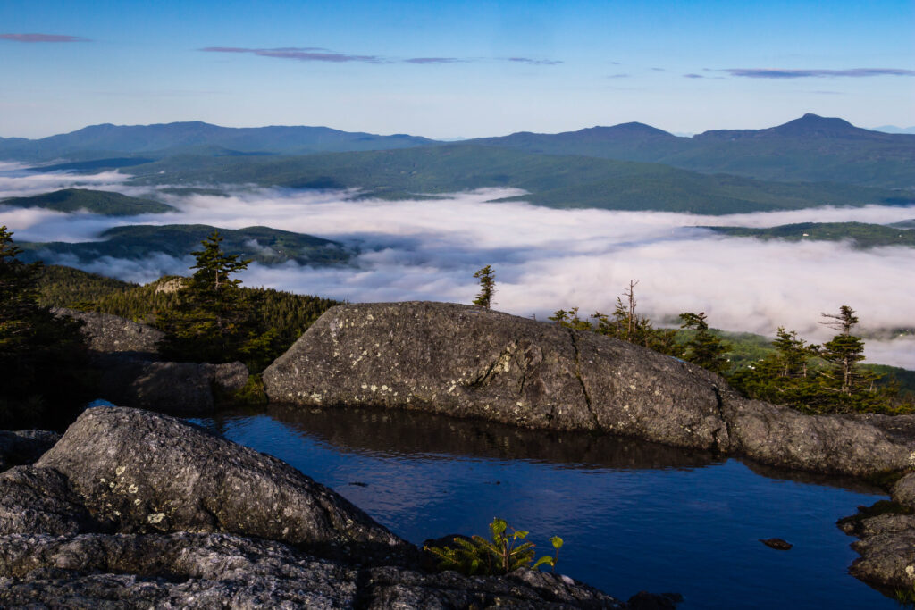
Earlier this hiking season, Vermont State Parks partnered with the National Weather Service’s Burlington office to raise awareness of the detailed recreation and mountain point forecasts the agency produces daily. Meteorologist Seth Kutikoff breaks down how to read a mountain forecast, and how to apply its findings to your next hike!
The National Weather Service local forecast offices provide their users weather forecasts geared towards public safety. Given user needs, many of these offices, such as ours in Burlington, decided to create recreation forecasts. We transmit these forecasts in the same fashion that all of our forecast products, including watches and warnings, are delivered. At a minimum, a new forecast is created twice a day. The Burlington office issues a popular marine forecast used by boaters on Lake Champlain and a mountain forecast geared towards hiking in the Adirondacks and Green Mountains. And yet, many people still do not know these forecasts exist! If that’s you, then this blog post is meant for you!
History
We have actually offered a mountain weather forecast in some form all the way back to the 1980s, long predating sophisticated computer models. An example from January 6, 1989, archived at the Iowa Environmental Mesonet, is below:
BUTV-WINTER SPORTS FORECAST
NATIONAL WEATHER SERVICE BURLINGTON VERMONT
345 AM EST FRI JAN 06 1989
WINDS AND TEMPERATURES FOR THE MOUNTAINS OF VERMONT TODAY
ELEVATION (FEET) TEMPERATURES WINDS (MPH)
2000 0 TO 10 10 TO 20
3000 -5 TO 5 15 TO 25
4000 -10 TO -5 20 TO 30
Years later when we started offering summertime mountain forecasts they looked like this:
RECREATIONAL FORECAST
NATIONAL WEATHER SERVICE BURLINGTON VT
1100 AM EDT WED JUL 6 2005
THE HIGHER SUMMITS FORECAST FOR VERMONT AND NORTHERN NEW YORK…
TODAY…MOSTLY CLOUDY WITH A CHANCE OF MORNING SHOWERS…THEN
A CHANCE OF SHOWERS AND THUNDERSTORMS IN THE AFTERNOON. NORTH WINDS
15 TO 25 MPH. HIGHS IN THE 60S..
THURSDAY…MOSTLY CLOUDY WITH A CHANCE OF SHOWERS AND THUNDERSTORMS.
NORTH TO NORTHEAST WINDS 15 TO 25 MPH. HIGHS IN THE 60S.
Then as we had the gained the ability to paint more detailed forecasts, we added a nighttime recreational forecast and the point forecasts:
.THE HIGHER SUMMITS FORECAST FOR VERMONT AND NORTHERN NEW YORK…
TODAY…MOSTLY CLOUDY. A CHANCE OF SHOWERS AND THUNDERSTORMS IN
THE MORNING…THEN SHOWERS LIKELY WITH A CHANCE OF THUNDERSTORMS
IN THE AFTERNOON. SOME THUNDERSTORMS MAY PRODUCE SMALL HAIL AND
HEAVY RAINFALL. HIGHS AROUND 60. SOUTHWEST WINDS 5 TO 15 MPH.
.TONIGHT…SUMMITS OBSCURED IN CLOUDS. A CHANCE OF SHOWERS AND
THUNDERSTORMS UNTIL MIDNIGHT…THEN SCATTERED SHOWERS AFTER
MIDNIGHT. LOWS IN THE MID 50S. SOUTHWEST WINDS 10 TO 20 MPH.
.TUESDAY…SUMMITS OBSCURED IN CLOUDS. PERIODS OF SHOWERS WITH A
CHANCE OF THUNDERSTORMS…MAINLY IN THE AFTERNOON. HIGHS IN THE
UPPER 50S. SOUTHWEST WINDS 10 TO 25 MPH.
Today, we generate twice daily mountain point forecasts for 19 summits in the Green Mountains and 25 in the Adirondacks.
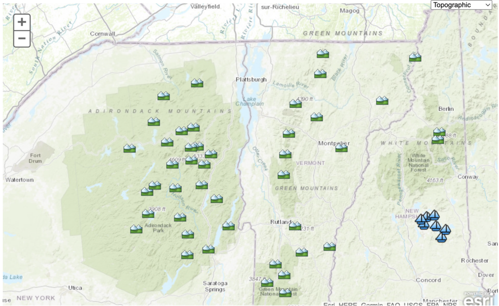
Purpose of the Mountain Point Forecasts
The mountain (or Higher Summits) point forecasts are a tool to plan an outing in the higher terrain, providing a more accurate and useful weather forecast than our standard weather forecast. Hikers often hear the reminder “It may be warm and sunny in town, but cold and windy up top.” Exposure to the elements on ridgelines and summits, such as lightning risk and wind chill, pose a threat to public safety. The expected weather included in a mountain weather point forecast, including sky condition and precipitation, temperature, and wind speed and direction, are all factors that can increase risk of hypothermia. The mountain weather forecasts give hikers another tool to prepare for a safe and enjoyable hike.
There are some commercial apps out there that specialize in mountain weather forecasts. While we can’t vouch for any of these as a government agency, we can say that your tax dollars do go towards the NWS Mountain Weather Forecast. With potentially spotty cell service/data in the proximity of the mountains, the output is text based, with these data tables requiring only limited data to load. When you come across a trail kiosk at Mount Mansfield and Camel’s Hump, and in the future other Vermont State Parks, you’ll see a QR code on a sign saying “Scan Below for Mountain Weather.”
Doing so will bring up the Mountain Point Forecast Text for the relevant mountain.
Reading a Mountain Point Forecast
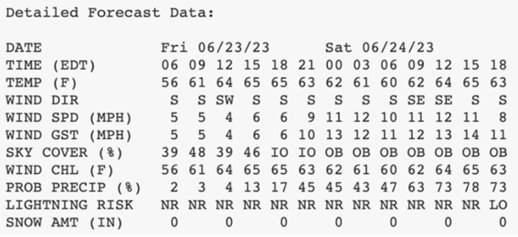 A typical forecast will run from this morning through tomorrow afternoon (36 hours), or this afternoon through the next two days (48 hours). So in this example, you’re reading a forecast likely updated around 3:30 AM on June 23, 2023 that gives you the weather forecast for 6 AM, 9 AM, 12 PM, etc. through 6 PM (18 EDT) on June 24, 2023. For each hour, we can see the most likely outcome for the following weather elements:
- Temperature
- Wind direction (in 8-point compass roses)
- Wind speed (sustained wind – the average wind during a 2 minute period at the observation time)
- Wind gust (maximum wind speed over the past 10 minutes)
- Sky cover
- Wind chill
- Probability of precipitation
- Lightning risk (NR – no risk, LO – low, MD – moderate, HI – high)
- Snow amount (6 hour accumulation, to the nearest inch). Note that the snow amount timeframe is always relative to UTC (eg. 06 UTC to 12 UTC). As an example, during the winter/standard time, the first SNOW AMT at 06 EST would be the forecast snow amount between 1 AM and 7 AM EST.
The sky cover has a nifty feature that incorporates forecast cloud base heights and layers of high relative humidity to predict if mountains will be obscured (OB), in and out of the clouds (IO), or above the clouds (AB, also known as undercast).
The lightning risk comes directly from probabilities (chance) or coverage of thunderstorms: a slight chance (or isolated storms) corresponds to low risk, chance (or scattered storms) corresponds to moderate risk, and likely (numerous storms) corresponds to high. I would definitely avoid hiking during a high lightning risk time, and be prepared to change plans in a low and moderate risk timeframe while aiming to hike as early in the day as possible.
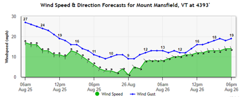
Before you hit the road, use the Enhanced Mountain Forecast, which has the same weather elements shown in hourly and graphical format. Note that wind direction is the direction the wind is coming from, which is depicted with an arrow (eg. arrow pointing upward is a south wind). In this example, you see a wind shift from south to northwest coinciding with a cold front. While this wind shift implies a trend towards high pressure, in many cases we will see mountains go from obscured to in and out of the clouds as scattered showers develop.
Limitations of Mountain Weather Forecasts
As with all forecasts, the Mountain Weather forecasts are just a snapshot of expected conditions in the future. The air is a fluid, so meteorologists are basically tracking waves across the globe. Even with the best weather models, which simulate the atmosphere at a high resolution in time and space, there is inherent low predictability in precipitation since it is dependent on so many meteorological factors.
We deal in probabilities for precipitation; as an example, it may snow 1 in 5 times when chances of precipitation are 20% at a given hour. Timing, amounts, and precipitation type in the cold season are particularly challenging to predict, even within 36 to 48 hours. While we do update the forecast when we think observations are deviating significantly from forecasts, we mostly rely on webcams, radar, and satellite data. None of this information can ensure the forecast matches the ground truth for all of the summits we forecast, so keep in mind that the forecasts may not capture reality, especially in changeable weather.
Using Forecasts to Plan Your Hike
As alluded to above, precipitation is more difficult to forecast than temperature, especially across a month or season. At the time of this writing, in Vermont there are equal chances of above and below normal precipitation across the meteorological fall (September through November). Above normal temperatures are likely, but consider that is just a probability and not a guarantee. Note we were in the same percent chance range back in May for above normal temperature across the meteorological summer (June through August), and most locations will end up near or on the cool side of normal during the summer.
As temperatures trend cooler and days shorter, we can expect to see intrusions of cold air from the north. A taste of chilly weather is expected in early September, for instance. Often cooler air masses come with breezy conditions, and these winds will tend to flow up-mountain. When combined with moisture, that then leads to showers (and snow showers) over the high terrain, and when our skin gets wet, we combine the winds and colder air to create a hypothermia risk. So in the mountain report, I would look for sky cover of OB and a wind chill below 40 degrees as signals to pack for cold weather.
In general, of course, you should carry at minimum the Ten Essentials (extra food, water, clothes, emergency shelter, sun protection, headlamp, first aid, fire source, first aid kit, repair kit). Learn about dressing for fall and winter hiking and how to protect yourself from backcountry emergencies and extreme summer weather.








Leave a Reply