

This is a guest post by Joe Bahr, one of GMC’s Thursday Volunteers and an amateur geologist.
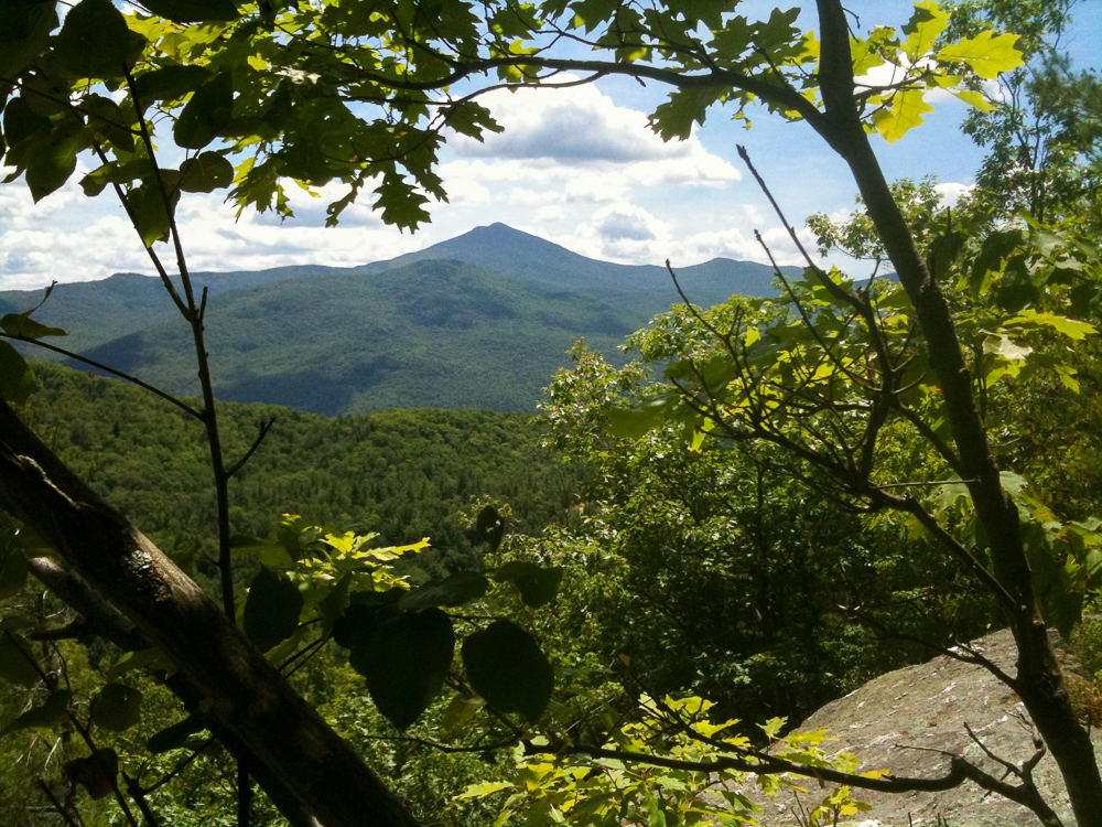
Camel’s Hump is the most recognized and unique mountain profile in Vermont. But how did it get that distinctive shape? The quick answer is the Ice Age.
The continental glaciers grew from a region near Hudson Bay, and thus moved southeast to reach Vermont. When the ice reached Camel’s Hump, it was at least 5,500 feet high, and might have been as much as 6,500 or even 7,000 feet high. From the glacier, one would only have seen a level surface extending as far as the eye could see.
Since the glacier was much higher than Camel’s Hump, it easily rode over the entire mountain. If one had been standing on the current summit during the Ice Age, the person would have been underneath almost a half-mile of ice. As the glacier continued its movement to the southeast, it scraped the western and northern slopes much as sandpaper would smooth and whittle wood. Thus these sides of Camel’s Hump are generally polished surfaces with no cliffs.
On the southern and eastern sides of Camel’s Hump, the ice gouged out huge chunks of rock along fracture lines. (A fracture is a zone where the rock easily separates. It is determined by the size and shape of the crystals that make up the rock.) This gouging action is termed “plucking” and the “plucked” rocks can be the size of automobiles or even small buildings. One example of a “plucked” rock in Vermont is Balanced Rock on the ridge of Mount Elmore.
This plucking action left the cliffs on the sides of Camel’s Hump. It also left additional cliffs further to the east that can be seen from the Dean Trail. More cliffs were created by Wind Gap and can be seen from the old beaver pond on the Dean Trail.
One can estimate the amount of rock that was removed by this “plucking.” Assume that Camel’s Hump had a rounded summit before the Ice Age (most summits have rounded shapes if they are “old” mountains such as the Green Mountains). If the mountain still has a mainly rounded shape, then very little of the mountain was removed by the glacier. If the mountain no longer has a rounded shape, then erosion was more severe. If the mountain is no longer rounded but does at least begin to curve downward on its south side, then less than half of the peak was carried away by the glaciers. If the peak appears to still be rising to a rounded shape, then more than half of the peak was carried away by the glaciers. To my eye, it appears that almost half of the south side of Camel’s Hump was removed by the glacier.
The same plucking action that created Camel’s Hump may have left steep slopes and cliffs on the south sides of many Vermont mountains. I say “may” because while Camel’s Hump has been studied and thus its formation has been reasonably well determined, most mountains have not had any formal research on the factors that created their present shapes. However, from their appearance, one can say that many mountains bear the classic features of being shaped by the glacier. Among them are Mount Hunger, Stowe Pinnacle, and Whiteface Mountain in northern Vermont. Further south, Mount Horrid also appears to be a classic example of glacial action. The cliffs on the north side of Interstate 89 between Bolton and Waterbury are another example and are easily viewed.
Not all steep slopes or cliffs were created by glacial ice. For example, Smugglers’ Notch appears to have been shaped by running water. It is believed that the water came from the melting glaciers. And there was a lot of water to melt – the ice was thick enough to extend almost a mile above the present height of Smugglers’ Notch. That amounts to an entire ocean of water because the ice extended for hundreds or even thousands of miles in all directions. So much water was tied up in the continental glaciers that the level of oceans around the world was more than 400 feet lower than it is today.
So the next time you see or climb Camel’s Hump, thank the Ice Age for giving us such a wonderful mountain.


Very interesting……but where did the name come from. My Father used to call it the Couching Lion….not crouching but couching..
Camel’s Hump was originally called “The Couching Lion.” According to our book “Place Names on Vermont’s Long Trail,” – Couching is a term used in heraldry and refers to an animal that is lying down but has its head held erect. The earliest known use of the name Camel’s Hump was by Zadock Thompson in 1830 as a replacement for Camel’s Rump, which was used by Ira Allen on a 1798 map.
couchant
in American English
(ˈkaʊtʃənt)
ADJECTIVE
1. lying down said esp. of animals
2. Heraldry
lying down or crouching, but keeping the head up
a lion couchant
couchant
in American English
(ˈkaʊtʃənt)
ADJECTIVE
1. lying down said esp. of animals
2. Heraldry
lying down or crouching, but keeping the head up
a lion couchant