

This post was written by GMC Member John Predom and previously appeared on his blog.
An Adventure for a Lifetime
40 years ago I was introduced to the Long Trail. The specific year I started hiking the trail is lost in my mind (maybe it was either 1971 or 1973?). What is clear is who I hiked with and where we hiked. It was my first big adventure. My best friends Steve Scales and Steve Merriam and I planned to hike from Route 140 near Wallingford to Route 100 at the base of Bromley Mountain. It was an approximately 50-mile hike and we allowed ourselves a modest 10 miles per day to get there. This was at a time before cell phones were thought of, except in a Star Trek series, and when our parents dropped us off we said we would see them in 5 days. How bold we were to go into the wild for 5 days with no way to communicate!
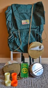
Our gear was nothing special: a nylon Canyonland external frame pack and some Boy Scout gear. We used Glad bags to waterproof our sleeping bags and wore them for rain gear on the wet days. We all had heavy sleeping bags, cooked on a Sterno stove, carried aluminum canteens and cook kits, and brought our telescopic fishing rods to try our luck at Little Rock Pond. I do not remember many of the details of that trip. I do remember staying in the shelter at Little Rock Pond but I do not remember catching any fish. I remember hiking in the rain, being on top of Bromley, and getting out a day early. We had to call our parents from a pay phone, then sit and wait for them to arrive. At the time, I did not know it was the start of my Long Trail adventure.
A year or two later we hiked from Route 103 north over Killington to Route 4. At that time the trail crossed at the top of Sherburne Pass instead of where it does now. I was recently reminded by my friend Kevin Arlund that he joined us on that trip.
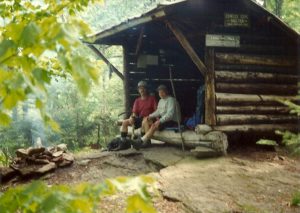
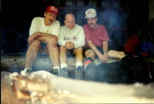
Years passed, I graduated from high school, joined the Air Force and forgot about the Long Trail; I did backpack on the Appalachian Trail in Virginia a little. When I returned to Vermont I did frequent hikes to White Rocks Cliff, but that was the only hiking I did until I moved to Bristol in 1985. There I made friends with a few guys that liked to hike. I backpacked from Lincoln Gap to Birch Glen Shelter with Craig Chase, Rick Palmeiri, Doug Richardson, Tim Potter, Sherry Roberts, and Tom Nostrand. Our intended trip was to Jonesville but we were out of shape and had overextended ourselves on the first day. We had also stashed a case of beer and some vodka in the stream near the cabin. The next day we woke up sore and hung over and a couple of the friends decided to hike out, hitchhike to their car, and then come back and rescue us. By the time they returned we had our gear and the empties by the roadside waiting for them.
I did the hike between Appalachian Gap and Lincoln Gap one more time. And then twice hiked from Birch Glen Shelter to Jonesville, once by myself and once with friends Rick Palmeiri and Doug Richardson. I set my boots too close to the fire on that trip and was unable to tie them up to the top; luckily I could still wear them.
The next planned hike was from Lincoln Gap to Route 4. I did that hike with my friends Tim Potter and Craig Chase. Places that stand out in my mind are Emily Proctor Shelter, Middlebury and Brandon Gaps, hiking through a field of stinging nettles and wondering what just happened! And coming face to face with the biggest snake I have ever seen in Vermont sunning itself on a rock at eye level on the trail! All this time I was still using my Sterno stove, Boy Scout cook kit, and water tablets; eating oatmeal and cup-o-soups and dehydrated meals from EMS. By this time I realized that I had hiked a good portion of the Long Trail and decided instead of repeating hikes that I had already done I would hike new ground from now on. Up until this point, I had been just drawing a line in my guide book each time I completed a section and retraced the lines when the first book wore out.
 Between 1987 and 1997 my hikes and camp outs were limited to day hikes and overnights. We had started a family and at first, I would backpack my daughter up Mount Mansfield, Camel’s Hump or Mount Abraham. When they got old enough I would tempt them up the trail with M & M’s. My oldest daughter Jessica hiked Skylight Pond Trail to Skyline Lodge where we tented. Another time I led a group of their friends on a winter hike to Birch Glen Shelter where we cooked hot dogs and drank hot chocolate. Lots of good memories on the side trails over those years!
1997 was the year! (Or at least I thought it was.) It was my intention to hike the whole Long Trail in one shot. I made a big investment in performance clothing, Gortex rain suit, used internal frame pack, water filter, non-stick mess kit, Whisperlite stove, two-person tent, NOLS cookbook, and a dehydrator. I planned and made my meals, packed boxes, arranged pick ups and drop offs, and was ready to go! I also bought a new pair of LLBean Gortex hiking boots.
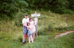
My family dropped me off at the Pine Cobble Trailhead in Massachusetts on a hot day in June. I can remember the black flies, mosquitoes, and storm clouds chasing me for most of my hike. I was keeping a logbook now and went by the trail name of “Snowdog,” acquired from my favorite RUSH album and my fondness for winter hiking. Here is an excerpt from my log:
“Hot and Hurtin”
I got to the Congdon Shelter at 5:30 PM. This 13-mile day almost did me in. I was so tired I ate cereal for supper. Thunder was chasing me most of the afternoon; it’s storming now. I BEAT THE RAIN! A guy named Chris showed up just before the rain. He just graduated from Middlebury College. I will be sleeping early tonight. Miss my girls already.
Stratton Pond is always beautiful, but the shelter was full when I got there. It had been a long day, but I decided I could make it to the next shelter, the William B. Douglas Shelter. When I got there someone had made an entry in the logbook that they had seen snakes in the walls earlier in the day and decided to move on. Looking on the bright side, I figured there wouldn’t be any mice in the shelter! Since I was the only one there I set my tent up in the shelter that night to keep the bugs away.
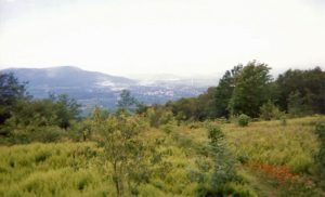
I made it to Bromley Mountain before I decided to call it quits; my sister met me there for supplies and I took a ride home instead. I had half-dollar-sized blisters on both heels and the duct tape was only aggravating things. What I remember most about this section was a lot of rain, humidity, wet socks, and bugs. If you stopped hiking you were eaten alive. I vowed never to backpack in June or July again. Several cool things happened on this hike as well; I ran into a hiker I had met at Emily Proctor Shelter a few years before, saw deer, and swam in a cool stream just before the end of the hike.
A bear greeted me on the next section from Jonesville to Route 108 in Stowe. I hiked this alone and walked up on a bear somewhere near Bolton at 10:30 AM. I wasn’t sure what to do and slowly started backtracking down the trail. When the bear saw me it took off like it had been shot out of a cannon! Climbing Mount Mansfield on a cold, wet day I realized I should have taken the bad weather bypass. It was the only place on the whole trail where I removed my backpack and threw it around a rock outcrop. Then shaking, I gingerly stepped around the outcrop, not looking down for fear of falling. At the Route 108 trailhead I came to realize how far it is to Stowe! I stashed my pack in the woods and walked forever! I had told my wife to pick me up at the McDonald’s and when I got there the McDonald’s no longer existed. I stood beside the road for hours waiting to flag her down. I had left my money and ID in my pack and was dehydrated and thirsty by the time she arrived.
My sister Kathy Elhers joined me from Route 108 to Route 15 near Johnson early in October 2008. We wore lots of blaze orange and I think people on the trail thought we were quite different. I consider this section the most difficult section. We spent the night at Whiteface Shelter. A couple came in, hiking south. They had hiked all over the country and Alaska and were finding the Long Trail very challenging. They came into camp after dark, coming down Whiteface a most challenging task. We would meet them on another day getting into a taxi at Route 108 with the man suffering from hypothermia. Our hike was not intended to end at Route 15, but my right knee swelled on the way down Whiteface to the shelter and I could barely bend it the next day. We shared our extra provisions and fuel with three thru hikers that were eating cold oatmeal and drinking water for a beverage. They were so thankful for fuel, real food, and tea.
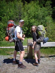
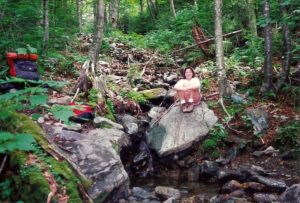
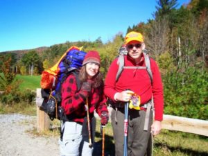
Memorial Day Weekend 2009, my daughter Allison and I hiked from Route 15 to Corliss Camp. I was excited to have her hiking with me and bought all the gear she needed to backpack. When I told her to bring her winter clothes she thought I was crazy and said, “DAD!” When snow was blowing sideways at Roundtop Shelter and we were all warm and snug in our sleeping bags playing cribbage she was no longer questioning her father’s prowess. I overextended her a little on the hike over Laraway Mountain to Corliss Camp, but she did not complain. We had a night of good food and more cribbage and unforgettable memories.
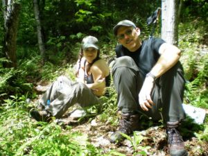
 Corliss Camp to Journey’s End was done with new trail friend Kathy Astrauckas. I had met Kathy while doing trail work for the Ottaquechee Section and she asked if she could join me on the hike.
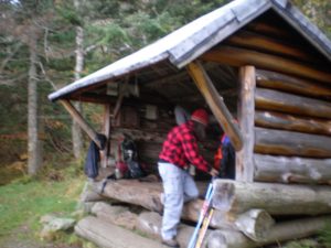
We spent the first night at Spruce Ledge Camp. I have never been a lightweight backpacker and some of the young people were smiling when they saw my pack. The next morning when they were shivering with all their gear on I was comfortable with clothes to spare. Trail memories are fun and two of the guys played music and told stories of hiking the whole AT; now they were doing the LT.
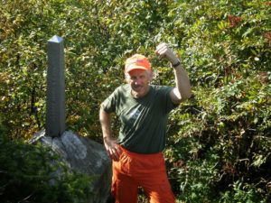 This was a wonderful section of the trail with few people and some amazing terrain! I met some interesting people along the way and remember the width of the trail changing north of Belvidere Mountain. I ate lots of wild blackberries on this section. Mmmm! Finally, the Canadian Border: we spent the night at Journey’s End Camp and hiked to the trailhead in a deluge where my mother was waiting. Yay!
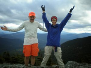
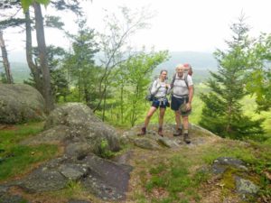
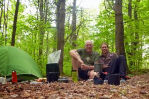
That left the final section: a short 6.3 miles between Route 103 and Route 140. I knew I could have day hiked it anytime, but I wanted to have a good final memory and end it with an overnight. That opportunity came this year (2013) when my good friend Dawn Sabotka motivated me to wrap this up! Instead of being a point-to-point, we made it an out-and-back for 12.6 miles. It was a perfect day for a hike and we took plenty of photos: first of the footbridge over North Clarendon Gorge and then all the Red Columbine along the trail. We dropped our packs at Minerva Hinchey Shelter, ate lunch, and then headed for Route 140. Once we reached our goal we returned and tented near the shelter. The morning hike out had some storm clouds hovering, but we stayed dry to the end. The final leg – finished.
I have so many good memories with friends, best friends, and family. I would not have wanted to do it any other way. I would still like to do it all in one shot, but there’s still time and I have the satisfaction of knowing that I have already completed it. I am also thankful for the people that have dropped me off and picked me up over the years; without them, it would have been difficult to accomplish.


A great read, and a great journey from beginning to end! Reading a horror novel in the woods at night…..Priceless!
Great article!!! You are one of a kind, give you lots of credit for all of this. Love ya Lorraine