

Hikers often ask if they can just keep hiking into Canada once they reach Journey’s End on the Long Trail. While a hiking trail does not exist exactly at the point the trail hits the border (nor does a checkpoint to legally cross over), there are trails in that area of Quebec. The below article was written by Pieter Crow and originally appeared in the August and November 1976 Long Trail News. The trails mentioned in the Editor’s Note in 1976 are now a reality.
Editor’s Note (August 1976): Pieter Crow’s description of his hiking experience on several mountains in Canada just north of Vermont comes at a particularly appropriate time. “Appropriate” because planning (and some work) is underway on Les Sentier de L’Estrie, the “Eastern Townships Trail, “which will pass through the area which Pieter describes. A status report on this new trail system is carried elsewhere in this issue. Pieter Crow, incidentally, is a GMC caretaker this summer, serving at the new Twin Brooks Tenting Area on Mt. Mansfield. We regret space limitations prevent carrying all of his report here; Part 2, which deals with Roundtop Mt., will appear in the November LTN.
Face north on the summit of Jay Peak and you can see foreign mountains just a few miles away. Look for an isolated, conical peak with ledges near the top; that is Owl’s Head (2450′). A little bit west is an eye-catching steep-sided ridge; that’s Sugarloaf (2150′), also called Elephantis. The highest and largest mass, closer and more to the west, is the Sutton Range and Roundtop (3175′). In the distance you might even see the rocky dome of Mount Orford (2875′). These summits and many more are the continuation of the Green Mountains in Canada’s Province of Quebec. Last summer I visited this little-known region and found a beautiful and rewarding area for exploring.
Before entering a new area, one should try to find out as much about it as possible. In the case of Canada’s Green Mountains, though, information is hard to come by. Unlike Ontario and the neighboring states, Quebec does not have guidebooks for its mountains. Too bad the Canadian hikers one often meets on the Long Trail can’t help instead. Some of them have never even hiked in their own country! Very few have hiked in les Cantons de l’Est, or the Eastern Townships, as the people of Quebec call the mountainous area north of Vermont. A little booklet, “Hiking Trails in Canada” (Published by Greb Hiking Bureau, 51 Ardelt Ave., Kitchener, Ont., Canada N2G 4H4.), suggests using logging roads and topographic maps to explore the Eastern Townships. The truth is, where trails do exist they are unsigned and known only to residents of the surrounding valleys. So, I entered Canada somewhat “blind”, armed with rumors of a trail up Roundtop Mt., three sentences about Owl’s Head from the LT guidebook, and a topo map. In the end the trip was a true exploration; I bushwacked more than I hiked on established trails.
 OWL’S HEAD
My first stop was Owl’s Head (2450′), a magnificent monadnock sitting on the shore of Lake Memphremagog. When the first European settlers arrived in the area, they found footpaths up the peak. Thus it is one of the few mountains that we know was climbed by the native American Indians. Perhaps the Indians had a strategic reason for climbing Owl’s Head; no other point commands such an extended view of the vast lake. The Indian paths became the basis for a hiking trail network that probably reached its greatest development in the first half of this century. From time to time, enthusiasts added new trails providing interesting circuits. The trail on the north side was always the most popular because it was easily accessible by road. The construction of the Owl’s Head Ski Area obliterated this path about ten years ago. Trail fragments between ski runs may well be remnants of the old path. In the late 19th Century a resort hotel known as the Mountain House stood on a small bay at the foot of the southeast slope. Until it burned, sometime in the 1890’s, the hotel served as a convenient base for rugged hiking on the south side of the mountain. Today, several trails are maintained by and for private landowners. The rest are forgotten or overgrown. They might still be rediscovered if one looks carefully through the undergrowth, but in a few years they’ll fade away forever.
Following the advice of the Guide Book of the Long Trail (1971 ed., p. 145), I used trails of the Owl’s Head Ski Area for the ascent. The ski area is about seven miles east of Mansonville, Quebec and one mile south of Vale Perkins. From the base parking lot I looked up at the northern slope, completely covered with ski trails. For one who prefers primeval scenery, it was a disappointing way to start a hike. Little did I know that Owl’s Head, like Mt. Mansfield, has many hidden facets despite the appearance of a ski development. On the way up. continuous views compensated for the distraction of cables and towers. Once above the chairlift I left the ski area behind and entered a different world.
A short rocky path led to the unusual summit. ” . . . The top is broken into numerous rock peaks by steep-sided clefts filled with dwarf mountain spruce.” That description was written by a visitor in 1915. Since then the spruce has matured, causing the “corridors” and “rooms” between peaks to become almost tunnel-like, with “ceilings” of branches overhead. The trees are low enough to allow partial view from the summit peaks, yet high enough to hide the little peaks from each other, a striking coincidence. A Freemasons lodge once used the largest of the “rooms”, or spaces, between peaks as an annual meeting place. Some words dated 1857 were carved into the rocks to commemorate the lodge’s first gathering there.
The south face of the summit with its myriad ledges and cliffs is a great place for rock scrambling. Below lies one of the largest forest tracts on Lake Memphremagog, thanks to landownership of the area by only one family. Bears live there, where the woods descend down to the water’s edge. On the eastern flank of the mountain, impressive cliff walls emerge right out of the lake. They are invisible from above and foiled my plan to circumambulate the base of Owl’s Head. All the while I kept an eye out for trails, with but little success. Nevertheless, I enjoyed many hours rambling in the nooks and crannies of this incomparable summit.

BEAR MT.
Several miles down the lake was my second hike, the long trailless ridge of Bear Mt. (2200′). A nearby farmer warned, “I been up there to hunt and it’s rough on the ridge, all up and down.” And so it was. I reached the ragged summit area after a steep but short bushwack from the nearest dirt road. Knobs and ledges seemed geologically similar to the little peaks on Owl’s Head. Instead of bare rock, though, there was a dense growth of trees and vegetation. Fern fields and thickets made good cover for a startled snowshoe hare. After a quick search, I climbed the knob that seemed highest and tied a register to the base of a tree. Descending from the summit through thick evergreens, the ridge traverse thankfully opened up into deciduous forest. I came to the International Boundary after an hour of pleasant woods walking. To the left was a glimpse of the lake. Eight miles to the right was the knoll where the Long Trail ended. In between, the thirty-foot wide border swath made a strange sight as it sliced through field and forest for miles in a straight line. That afternoon I strolled on back roads and pastures near North Troy (Vt.) village. Always above were superb views of Jay Peak and the Green Mts. of Quebec.
Editor’s Note (November 1976): We continue here the second part of Pieter Crow’s description of his hiking experience last summer on several mountains in Canada just north of Vermont (the first part appeared in the August LTN). Pieter served as GMC caretaker at the Twin Brooks Tenting Area on Mt. Mansfield during the summer and at Taft Lodge on the mountain during the fall. His home is in Groton, Mass.
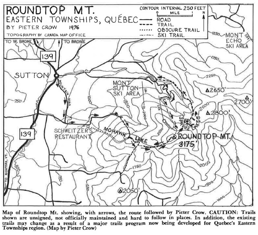
The Sutton Mountains form a considerable barrier in the Eastern Townships of Quebec. They start near the International Boundary about six miles from the north end of the Long Trail. For twelve miles no roads cross the ridge crest as it heads northeasterly before finally dropping down to Bolton Pass and Route 243. Five major summits exceed 2500 feet; Roundtop Mt. is highest at 3175′. Despite their modest height, the mountains average 1500 feet above the valley towns and farms. On the southeast edge is the greatest slope, where Roundtop rises 2700 feet above the Missisquoi River in a horizontal distance of 2 3/4 miles. Features include four ponds above 2300 feet (more about these later) and two ski areas: Mount Sutton and Mount Echo. The best way to the ski areas and hiking trails is through the town of Sutton, on the west side of the range.
To reach Sutton from my camp at the base of Bear Mt, I went sur le pouce, French-Canadian slang for hitchhiking (literally, “on my thumb”). Like much of Vermont this was farm and forest country with plenty of dirt roads. If not for some friendly farmers I would still be there waiting. Occasional small villages like Vale Perkins, Potton, and Brome would be indistinguishable from Vermont villages but for signs in French. The main road went over Bolton Pass (800′), which turned out to be a low, gradual rise in the hills at the northern end of the Sutton Mts. Some of the drivers who picked me up had hiked in the range and told about a trail to Mohawk Lake.
From the center of Sutton, I hiked up Mountain Road to Schweizer’s Farm and Restaurant. Although a trail ascended directly to Mohawk Lake from the restaurant, I was informed of a better trail farther up the road. About a mile beyond I found the trailhead on the right. An abandoned car marked the spot where yellow blazes led up steeply on a well-cleared but unsigned path.
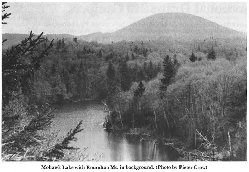
Half an hour later I came to an attractive pond. For three days Mohawk Lake was my water supply and its shore my campsite. During my stay, the only other human visitors to the pond were two men who came up for a morning dip and fifteen youth hostelers on a day trip. The rest of the time I had the company of the woods, croaking frogs, a curious rabbit, and the mysterious pond all to myself. The pond, about 30 yards wide and 200 yards long, nestled between three little hills that shut out distant views. In such a setting there was a strong sense of isolation and eternity.
Several Sutton residents told me that Mohawk (or Mohonk) Lake filled the crater of an extinct volcano and is more than 200 feet deep. The pond is deep but the volcano idea is a widespread misconception. The Sutton Mountains are simply a northern finger of the Appalachian Mountains, which were formed by other forces. As for the depth, well, I won’t believe that “200 feet or more” until someone lugs a boat with sonar up there.
 ROUNDTOP MT.
On a day dawning cloudy and threatening, I arose for the exploration of Roundtop. All four trails emanating from the pond went down. The only alternative was to head off into the woods without trail and follow a ridge to the summit. Halfway up, a familiar sign of man caught the corner of my eye: blazes. Yellow blazes leading up. The trail to Roundtop! I found the summit had recently been cleared in connection with surveys for the International Boundary Commission. But the clouds allowed no views and a light drizzle fell.
Now to find Spruce Lakes, the feature which originally brought me to Canada. Several years before I had been browsing in a map depository library when three small ponds caught my attention. A closer look showed them to be on the northeastern slopes of Roundtop Mt. at about 2500 feet. The biggest surprise was that all three were within a quarter-mile radius! No trails led to them on the map. These ponds I would have to see!
Once again I entered the woods without trail. The map showed just a mile down to the ponds, but it was a hard mile in the foggy, wet conditions. With visibility less than 100 yards, route-finding skills had to be used to the utmost. For an hour and a half I groped through the forest trying to stay on a compass line. Cliffs kept detouring me. Finally I stood on a ridgetop, too high. I dropped down and soon felt the bushwhacker’s ultimate satisfaction. There lay the corner of a pond, mist floating over its surface. One of the Spruce Lakes! As I followed the shoreline a strange feeling emerged from the back of my mind. Something was funny here. But of course! There was no trail around the pond. Could this really be so remote that a path hadn’t been beaten around it? I rushed through the woods and found a second pond. Good, this wasn’t a dream. Suddenly a sound from the water – thwap! A beaver! I sat down to watch. After re-appearing from under water, he watched back while swimming up and down the pond to gauge the meaning of my presence. Finally the beaver vanished, perhaps satisfied that I meant no harm. I continued alongside thick spruce woods that gave the name to these ponds.
A large shape on the shore loomed ahead in the fog. Oh, no – a hut! After the exhilarating discovery of these pristine ponds and woods I was greeted by a dilapidated, dirty hut. A register inside showed that people rarely visited the place, yet there were large amounts of litter lying around. Somebody had been disregarding the “Carry In- Carry Out” rule!
Beside the hut was a yellow-blazed trail. (This was the sixth yellow blazed trail I’d found on Roundtop; they were built by Jim Wellbridge of the Canadian Youth Hostels Association.) I followed it along the outlet brook of the hut pond to the prettiest of the three ponds, where the water was an eerie dark color. In good weather there would be views from the open shoreline. Beaver had been at work here too. And there was a miniature gorge cut into the rock at the pond’s outlet. A little farther on, the trail passed the outlet of the first pond, which was not connected to the other two ponds. Pristine it was not; a small cement dam held back its waters. The trail went on down the mountain and came out on the access road to the Mount Sutton Ski Area. I reascended Roundtop by ski trails and an obscure path. This time the clouds cleared enough for a good look into the deep valley of the Missisquoi River. Barely visible through the haze was the massive outline of Jay Peak. Back at Mohawk Lake I hit the sack after a tough twelve-hour hike / whack.
Next morning I returned to Vermont, well satisfied with my adventures. In six days north of the Long Trail, I had seen that the splendors of the Green Mountains do not end at the Canadian border.


Amazed to see this article from so many years ago republished from LTN. I had so many wonderful hiking experiences during my decade living in Vermont in the 1970s and 1980s. Several years ago I returned to Camels Hump and Mt Mansfield. So much of nature’s beauty on display! Had a special treat on the summit of Camels Hump when I ran into Ben Davis, former GMC Executive Director. In 1977 we worked together on the Hump, he as caretaker at Montclair Glen Shelter, myself as Ranger-Naturalist. Forty-plus years after my explorations north of the Lt, I am still getting outdoors, and most grateful for the opportunity. Now living in Kunming, China, I write travel articles about Yunnan Province, mostly about hiking and mountain climbing, for http://www.GoKunming.com. I hope to continue walking for years to come or as long as I am able, and look forward to future hikes in the beautiful Green Mountain state!