


Camel’s Hump, or Tawapodiiwajo ( Abanaki name meaning “place to sit” or “saddle mountain” or “mountain seat”), is the only undeveloped peak higher than 4,000 feet in Vermont. Its iconic domed silhouette, recognizable anywhere from driving on Interstate 89 or on the Vermont State Quarter, is the result of glacier activity in the last Ice Age, 13,000 years ago.
There are countless ways to explore Camel’s Hump and hike its trails.There are seven trails on the mountain. The Long Trail runs about 11 miles south to north over the summit and down to the Winooski River Valley. The Burrows Trail, recently restored by GMC, carries thousands from Huntington to Camel’s Hump summit. On the mountain’s east side, the Monroe Trail is another popular route to the top. Forest City, Allis, Dean, and Alpine round out the network. Choose the trail or destination that’s perfect for you:
Purchase a Camel’s Hump Area Trail Map
From Huntington
- Old CCC Camp via Forest City Trail – Easy
- Montclair Glen Lodge via Forest City Trail – Moderate
- Camel’s Hump Summit via the Burrows Trail > Long Trail South – Difficult
- Camel’s Hump summit via Forest City > Long Trail North > Burrows Loop – Difficult
Trailhead Access: From Main St in Richmond, head west on Bridge Street to the intersection after the Old Round Church. Turn right on Huntington Road. Continue for 8.9 miles, passing through downtown Huntington. In Huntington Center, turn left onto Camel’s Hump Road. Continue 2.5 miles, climbing the steep dirt residential road, to the either the upper or lower Burrows/Forest City parking areas. Camel’s Hump Road occasionally closes due to severe mud conditions. Please obey all posted signage.
If both parking lots are full, please respect our neighbors and do not park along the road. Instead, try one of these other great hikes nearby:
- Theron Dean Shelter or Molly Stark’s Balcony from Appalachian Gap,
- Birch Glen Shelter via the Beane Trail
- Bamforth Ridge Shelter or Duxbury Window from Duxbury Road
Old CCC Camp via Forest City Trail – 0.6 mi round trip, approx. 150 ft elevation gain
From the parking area, follow the blue-blazed Forest City Trail as it gently traverses the side of the hill. The trail soon descends to Brush Brook. Cross the brook on a new bridge built by GMC crews in 2024. Once you cross Brush Brook, keep an eye out for a stone furnace on the right/south side of the trail. This marks the abandoned Forest City Civilian Conservation Corps camp built and used in the 1930’s. If you look carefully, you can see other signs of the old camp. Return the way you came.
Montclair Glen via the Forest City Trail – 4.4 mi round trip, approx. 1,700 ft elevation gain
From the lower parking area, follow the CCC camp directions above. From the CCC camp it is another .5 mi to the intersection with the Forest City Connector Trail, which leads to the Upper FC/Burrows lot. Stay on the main trail as it climbs steadily for 1.4 mi through beautiful terrain. The trail ends at an intersection with the Long Trail. Turn right/south on the white-blazed LT and follow it for 200ft to Montclair Glen Lodge.
Montclair is a great spot for a picnic or for a break before heading to the summit (see Difficult description below). When you begin your descent, be sure to not to miss the left turn for the blue-blazed Forest City Trail. For a shorter hike, start at the Upper Forest City/Burrows parking lot at the end of Camel’s Hump Road. At the kiosk immediately after the trailhead, turn right on the Forest City Connector Trail. When it ends at the Forest City Trail, turn left to head up towards Montclair.
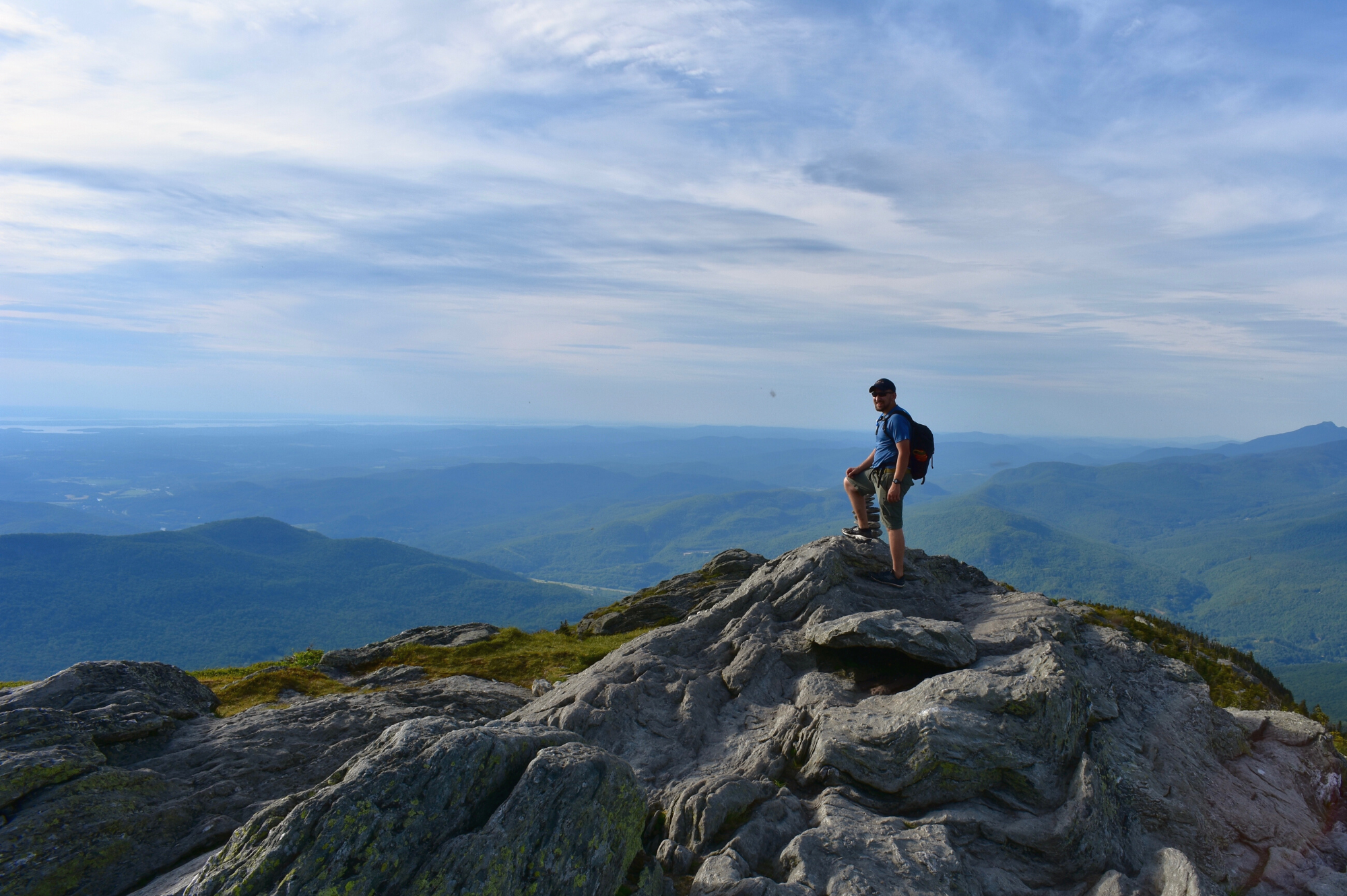
Camel’s Hump Summit via the Burrows Trail > Long Trail South —4.8 mi round trip, approx 2,400 ft. elevation gain
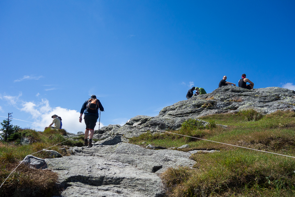
See the results of a three-year restoration of the extremely popular Burrows Trail, completed by GMC and FPR in 2024. This trail is steep and difficult, but the work put in by crews over the last three years has made the footing a lot more manageable. Park in the Burrows Trailhead lot at the end of Camel’s Hump Road in Huntington. Enter the woods, cross a bridge, and begin ascending moderately and steadily. There are a few new re-routes on the lower part of the trail that were built with sustainable grades, and hundreds of new stone steps to help hikers and slow the flow of water on the trail. after 2.1 miles, reach the “Hut Clearing,” where the Long Trail, Monroe Trail, and Burrows Trail all meet. Turn right, following signs for Long Trail South, to ascend another .3 miles to the summit. This portion of the trail is above treeline and may require some careful footing and light rock scrambling. Take in the 360-degree view from the summit, then return the way you came, taking care at the Hut Clearing to take the Burrows Trail back to your car.
Camel’s Hump summit via Forest City > Long Trail North > Burrows Loop – 5.8 mi round trip, approx. 2,461 ft elevation gain
NOTE: We highly recommend bringing a map and giving yourself a full day for this hike. Do not attempt this loop if there is a threat of thunderstorms as route is above treeline for 0.5 miles, offering little protection from wind, rain, and lightening. The route also includes an additional 1.5 mi of extremely challenging terrain which at times requires the use of hands, and which is exponentially more difficult in the rain or dark.
This challenging loop to is a fun alternative to the popular out-and-back Burrows route. A Vermont classic, it takes you to one of the highest points in the state! Starting at the Upper Forest City/Burrows lot, take the Forest City Trail up to the Long Trail (see Montclair Glen hike description above). Turn left/north on the white-blazed Long Trail and stay on it through a four-way intersection in Wind Gap. From Wind Gap, the LT climbs 1.5 rugged miles to an intersection with the Alpine Trail. This section of the LT includes rock scrambles which may be challenging for some dogs.
Soon after passing the Alpine Trail junction, you’ll emerge from the trees and see a large wooden sign announcing that you are entering the fragile Alpine Zone. Above this point, please take care to walk only on rock, as the plants are easily permanently damaged by foot traffic. The summit is .2 mi after the junction. NOTE: The south side of the summit is extremely steep open rock and may not be appropriate for people with an intense fear of heights. Ascent will be significantly more difficult in the rain or fog.
Once you have enjoyed the view at the summit, continue on the LT north for .3 mi to “Hut Clearing.” This is a large opening just after the trail comes down below treeline. To descend, turn left on the blue-blazed Burrows Trail from the clearing. Be sure to double-check the trail sign, as multiple blue trails connect to this clearing. Follow the Burrows Trail the full 2.1 mi back down to the parking lot.
From Duxbury Road in Bolton

- Gleason Brook Bridge on the Long Trail – Easy
- Duxbury Window on the Long Trail – Moderate
- Bamforth Ridge Shelter on the Long Trail – Difficult
- Winooski River Footbridge – Easy, accessible
Trailhead Access: From the intersection of Main Street and Bridge Street in Richmond, continue south on Main Street/Route 2 for 3.5 miles. Turn right on Cochran’s Road, then left on dirt Duxbury Road. Pass the south entrance of the Winooski footbridge. After 3.5 miles, the parking area is on the right.
Gleason Brook Bridge on the Long Trail – 1.2 mi round trip, approx. 200 ft elevation gain
This is a fun, short hike popular with small kids. From the parking area, hike .6 miles south on the Long Trail to the bridge over Gleason Brook. Relax by the stream and enjoy the sights and sounds of the forest! Note: This is an easier option than other hikes, but the footpath is still rugged and walking surfaces may be unstable.
Duxbury Window on the Long Trail – 3.2 mi round trip, approx. 800 ft elevation gain
A great option on a clear day. From the parking area, hike 1.6 miles south on the Long Trail to a beautiful lookout with a bench. Note: Most of the hike is a gradual incline, but the trail is fairly steep for a short stretch just before the Window.
Bamforth Ridge Shelter on the Long Trail – 5.8 mi round trip, approx. 1,600 ft elevation gain
For a longer trip, try hiking all the way to Bamforth Ridge Shelter. From the parking area, hike 2.9 miles south on the Long Trail up rugged terrain and over rock ledges. You’ll cross Gleason Brook, pass Duxbury Window, and experience some of the quiet solitude that upper Bamforth Ridge is known for.
Winooski River Footbridge
This 224-foot Long Trail suspension bridge, built and maintained by the Green Mountain Club, is accessible from Duxbury Road on the south side of the Winooski River. To reach the bridge, park in the small designated lot adjacent to the footbridge on Duxbury Road. The bridge is wheelchair accessible and you can enjoy looking at the mountains from the footbridge and enjoying the river running below you.
From Duxbury (access via Waterbury)
- Camel’s Hump View Trail – Easy, universally accessible
- Hump Brook Tenting Area – Moderate (Bonus hike: Dean Trail beaver pond lookout!)
- Camel’s Hump summit via Monroe Trail > Alpine Trail > Monroe Trail Loop – Difficult
Trailhead access: From the Waterbury roundabout, turn onto US 2 East/VT 100 South. Turn right on Winooski St to cross the river, then turn right on River Rd, also called Duxbury Rd. In 3.9 mi, you’ll come to an intersection with an arrow pointing towards Camel’s Hump State Park. Turn left onto Camel’s Hump Rd. After about 3 mi you will see a “Welcome to Camel’s Hump State Park” sign.
Camel’s Hump View Trail – .75 mi round trip, approx. 130 ft elevation gain
This lollipop-style loop trail features multiple gorgeous views of Camel’s Hump, which are especially good as the leaves begin to fall in autumn. The trail also features several benches, which offer nice rest spots.
From the sign at the parking lot, head out on the main path. Soon you will come to a split where you can go clockwise or counterclockwise on the trail. Whichever direction you choose, be sure to stay on the wide, blue-blazed Camel’s Hump View Trail, as there is a cross-country ski trail which crosses it at one point.
NOTE: This is a “universally accessible trail.” The trail surface is dirt and gravel, and may not be passable by wheelchairs designed for smooth surfaces, especially once fallen leaves are on the path.
Hump Brook Tenting Area via Monroe Trail and Dean Trail – 3 mi round trip, approx. 950 ft elevation gain
From the parking lot, head up the blue-blazed Monroe Trail, which climbs steadily through beautiful open woods. At the junction at 1.3 mi, turn left on the blue-blazed Dean Trail. After 0.2 mi, you will reach a small ravine spanned by a beautiful wooden bridge built by the Vermont Youth Conservation Corps. Very soon after the bridge, turn left at the sign for Hump Brook Tenting Area. There is a picnic table for a lunch break, as well as a lovely small brook. Return the way you came.
If you’re feeling ambitious, continue up the Dean Trail another 0.7 mi until you see a short trail made of stepping stones on your right. Follow this a very short ways to a breathtaking lookout of a beaver pond with the cliffs and summit of the mountain towering above. Return the way you came.
Camel’s Hump Summit – 6.6 mi round trip, approx. 2,583 ft elevation gain
We highly recommend bringing a map and giving yourself a full day for this hike. Do not attempt this loop if there is a threat of thunderstorms as route is above treeline for 0.5 miles, offering little protection from wind, rain, and lightening. The route also includes multiple critical intersections, which are much more easily missed in the rain or dark.
From the parking lot, head up the blue-blazed Monroe Trail. At the junction at 1.3 mi, stay right on Monroe. At 1.2 mi, turn left on the yellow-blazed Alpine Trail, which climbs steeply for .5 mi. As you reach the top of the Alpine Trail, keep an eye out for a very well-worn path on the left. This very short detour leads to the wing of a B-24J Liberator military airplane that crashed in 1944, killing all but one of the men aboard. Please be respectful of the site if you visit.
When you reach the end of the Alpine Trail, turn right on the white-blazed LT to head north to the summit. Soon you will emerge from the trees and see a large wooden sign announcing that you are entering the fragile Alpine Zone. Above this point, please take care to walk only on rock, as the plants are easily permanently damaged by foot traffic. The summit is .2 mi after the junction.
NOTE: The south side of the summit is extremely steep open rock and may not be appropriate for people with an intense fear of heights. Ascent will be significantly more difficult in the rain or fog.
Once you have enjoyed the view at the summit, continue on the LT north for .3 mi to “Hut Clearing.” This is a large opening just after the trail comes down below treeline. In the clearing, turn right on the blue-blazed Monroe Trail. Be sure to double-check the trail sign, as multiple blue trails connect to this clearing. Follow the Monroe Trail the full 3.1 mi back down to the parking lot.
A Day in The Area Itineraries
Itinerary One
Map It: Itinerary Directions
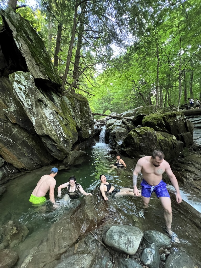 Hike Duxbury Window and admire the view over I-89. When you return, drive back down Duxbury Road towards Richmond and turn left on Honey Hollow Road. If there is room to park in the pull-offs, you can explore the trails and waterfalls of a branch of Preston Brook here. There are a few successional swimming holes perfect for a refreshing post-hike dip.
Make your way back to downtown Richmond and, depending on hunger level, stop at Stone Corral for delicious taco + beer combinations; Stone’s Throw for creative pizzas in an outdoor garden; or the creemee window at Big Spruce for a classic VT soft serve.
Finally, head to Volunteer’s Green in downtown Richmond – browse the farmer’s market on Friday evenings, catch a Little League game, or relax while the kids burn off any remaining energy on the playground.
Itinerary Two
 Map It: Itinerary Directions
Hike the Burrows Trail and see if you can spot the new staircases built by trail crews over the past few years.
Make your way back down Camel’s Hump Road to Huntington Road and turn right to head back to Richmond. Stop at the Jubilee Farmstand for a refreshing maple lemonade and variety of fresh and prepared foods to refuel after your hike.
Then, continue back towards Richmond and stop at Horseshoe Bend, a parking lot, trails, and swimming area managed by the The Green Mountain Audubon Center. Park at P2 on the map and take the river trail to the bend, perfect for wading, lounging, exploring, and jumping off a large rock.
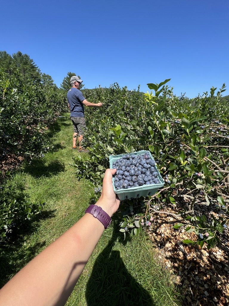
Finally, end your day at Owl’s Head Blueberry Farm, with pick your own blueberries, live music, and picnic spots galore.


