Bark Mulch Packing Instructions
Thank you so much for offering to pack bark mulch to a GMC composting privy! This is a huge weight off our shoulders (literally). Bark mulch is absolutely essential for our composting process and we couldn’t do what we do without your help. Learn more about the composting process in From the Field: Bathroom Talk at the Little Rock Pond Composting Privy.
For bark mulch packing, you should have a backpack at least 50L in capacity to hold your personal gear and the bag of mulch.
When hiking in bark mulch be sure to plan ahead and prepare for your trip. As a refresher, here are the 10 essentials for a day hike and some tips and trips for a successful outing.
Sign up to be contacted when a shelter is critically low on mulch and we need resupplying support!
For any further questions that haven’t been answered, contact Green Mountain Club Volunteer Coordinator!
Picking-up Bark Mulch
Green Mountain Club
4711 Waterbury Stowe Rd
Waterbury Center, VT
05677
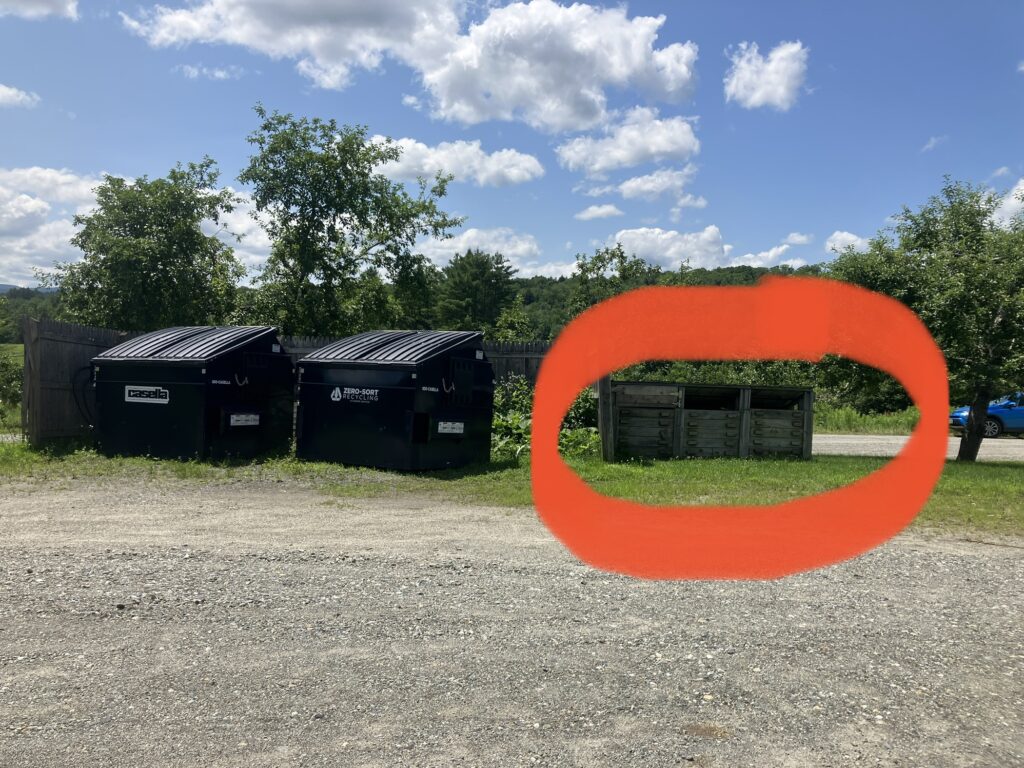
Details: The bark mulch is kept inside of the two wooden bins to the right of the dumpsters. There is a shovel and burlap sacks inside of the bins.
- Burlap sacks and a shovel are inside the bins.
- Using the shovel, fill the burlap sacks to desired weight. Take as many bags of mulch as you expect to pack-in throughout the season.
- It is a good idea to test that the size mulch sack you have will fit into your backpack. It does best in the center of your backpack, close to your back. Try putting rain gear and an extra layer in the bottom of your backpack, then bark mulch, and top it with your frequent snacks or water bottle.
- Carry mulch into any of the privies at the shelters below.
PRIVIES REQUIRING MULCH
Organized south to north, here are the privies that require bark mulch. All privies listed below are accepting bark mulch. Driving directions to each trailhead are listed below.
- Stratton Pond Shelter
- Spruce Peak Shelter
- Bromley Shelter
- Peru Peak Shelter
- Griffith Lake Tenting Area
- Little Rock Pond Shelter
- Churchill Scott Shelter
- Battell Shelter
- Glen Ellen Lodge
- Theron Dean Shelter
- Montclair Glen Lodge
- Hump Brook Tenting Area
- Bamforth Ridge Shelter
- Butler Lodge
- Taft Lodge
- Sterling Pond
AT THE PRIVY

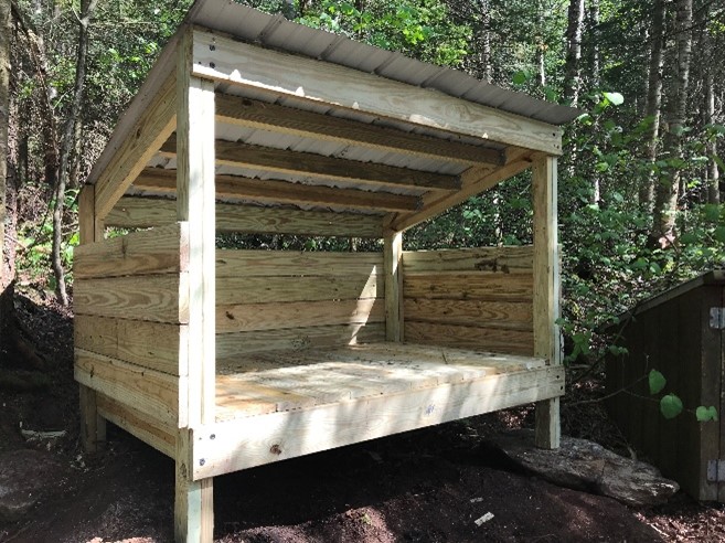
When you arrive at the shelter, find the privy. Behind or next to the privy, look for a short, three-sided structure with an angled roof (the drying rack). Please place the bag with mulch inside the drying rack.
Please leave the mulch in the bag — do not dump it into the drying rack! The mulch-looking material in the rack is actually composted waste in the final stage of the process, so we don’t want to mix it with fresh mulch.
Report Your Hours!
When you finish hiking for the day please complete the Bark Mulch Packer Report to submit your hours and let us know you’ve made the trip.
Submit a Bark Mulch Packer Report
If we become particularly short on any site we will also reach out!
Thank you!
For questions or concerns, please contact:
Kate Songer, Volunteer Supervisor
[email protected]
Site Driving and Hiking Directions
We strongly suggest bringing a Long Trail Map, 6th Edition or downloading Avenza and purchasing the Digital Long Trail Map, 6th Edition. Also, Trailfinder.info is another great source for hike details to most of these sites.
Stratton Pond Shelter via Stratton Pond Trail
Driving Directions
Western approach via U.S. 7: From U.S. 7 take exit 3 (Arlington) and proceed 0.1 mi. west on Vt. 313 to a right turn onto South Road. Follow South Road 0.6 mi. to its end on Kansas Road. Turn right and proceed 0.7 mi. to a fork just after crossing a bridge. The right-hand fork is Kelley Stand Road, which continues east 10.8 mi. to the LT. Parking is on the north side of the road just beyond the bridge over the East Branch of the Deerfield River.
Western approach via Vt. 7A: From Vt. 7A, follow East Arlington Road east for 1.0 mi. and turn right just before a bridge onto Old Mill Road. Follow Old Mill Road, which becomes Kansas Road at the Sunderland town line, 2.4 mi. to a fork just after crossing a bridge over Roaring Brook. The right-hand fork is Kelley Stand Road, which continues east 10.6 mi. to the LT. Parking is available on the north side of the road just beyond the bridge over the East Branch of the Deerfield River.
Eastern approach: From Vt. 100 in West Wardsboro, 0.5 mi. south of the post office, 8.5 mi. south of Vt. 30 in East Jamaica and 13.6 mi. north of Wilmington, follow Stratton-Arlington Road west 3.4 mi. to the town of Stratton and another 3.4 mi. farther to the LT parking lot on the north side of the road just before crossing the bridge over the East Branch of the Deerfield River.
Hiking Directions
Stratton Pond Shelter is accessed through the Stratton Pond Trail which is 3.7 miles. At the end of Stratton Pond Trail turn right for a spur to Stratton Shelter. The privy is one the left of the trail 100ft before the shelter.
Spruce Peak Shelter via Long Trail South
Driving Directions
Vt. 11 and Vt. 30:
This LT crossing is 5.9 mi. east of Vt. 7A in Manchester Center, 4.5 mi. east of the U.S. 7 interchange east of Manchester Center, and 0.5 mi. west of the junction of Vt. 11 and Vt. 30 south. There is a large paved parking lot on the north side of the road.
Hiking Directions
Use caution when crossing this highway, and hike on the LT 2.8mi. south to a spur leading west 0.2 mi to Spruce Peak Shelter. The privy is on a spur trail to the right of the shelter.
Bromley Shelter via Long Trail North
Driving Directions
Vt. 11 and Vt. 30:
This LT crossing is 5.9 mi. east of Vt. 7A in Manchester Center, 4.5 mi. east of the U.S. 7 interchange east of Manchester Center, and 0.5 mi. west of the junction of Vt. 11 and Vt. 30 south. There is a large paved parking lot on the north side of the road.
Hiking Directions
From the parking lot, start on the LT North and follow abandoned old Vt. 11, before turning sharply left (17.6 mi.) to enter the woods. Cross a brook over an I-beam bridge, pass under a power line, and climb gently to Bromley Brook (18.2). Cross over a bridge and continue along an old logging road. Turn left off the logging road and ascend toward the ridgeline. A spur (19.5) leads east 100 yds. to Bromley Shelter.
Griffith Lake Tenting Area/Peru Peak Shelter via Griffith Lake Trail and Long Trail South
Driving Directions
USFS Road 21 at Mad Tom Notch.
This LT intersection is 4.0 mi. west of Peru. From Peru’s J. J. Hapgood Store (0.3 mi. north of Vt. 11, 3.5 mi. east of the junction of Vt. 11 and Vt. 30 south or 4.4 mi. west of the junction of Vt. 11 and Vt. 100 south), follow the Hapgood Pond Road 1.0 mi. to North Road. Take the initially paved North Road 0.5 mi. beyond the end of the pavement to the second left, which is the gravel-surfaced Mad Tom Notch Road. Follow this road 2.1 mi. to the height of land in Mad Tom Notch and the LT. From there, continue driving Mad Tom Notch Road and come to an intersection of Mad Tom Notch Road and FR 58. Turn right on FR 58 and park at the Griffith Lake Trailhead.
Hiking Directions
Hike in the Griffith Lake Trail 2.2 miles until reaching the LT. When reaching the LT turn right (south) for Griffith Lake Tenting Area and Peru Peak Shelter.
Little Rock Pond Shelter via Long Trail North
Driving Directions
USFS Road 10:
From U.S. 7 in Danby, follow USFS Road 10 3.2 mi. east to the primary parking lot (paved) at the west trailhead.
Hiking Directions
At the LT North kiosk leave the pavement and follow an old woods road north. Cross Little Black Branch over an I-beam bridge, then recross it over large rocks. Travel over numerous puncheon and proceed to the south end of Little Rock Pond and the Little Rock Pond Loop Trail. Just beyond lies the Little Rock Pond Shelter and the privy is off behind the shelter.
Churchill Scott Shelter via Long Trail South
Driving Directions
U.S. Route 4
This trail crossing is 8.6 mi. east of U.S. 7 in Rutland, and 1.0 mi. west of the crest of Sherburne Pass. An unpaved lot on the south side of the highway provides ample parking. The Catamount Trail shares this highway crossing.
Hiking Directions
From this parking lot, hike south on the LT 1.9 miles to Churchill Scott Shelter.
Battell Shelter via Battell Trail and Long Trail North
Driving Directions
Lincoln Gap Road at Lincoln Gap
The LT crosses this steep, winding road at Lincoln Gap, 4.7 mi. east of Lincoln and 8.1 mi. east of its junction with Vt. 17 and Vt. 116 in Bristol. The crossing is also 4.7 mi. west of Vt. 100 in Warren. There is roadside parking at the crossing and a large secondary parking lot just east of the trail on the road’s south side.
Hiking Directions
Climb north out of Lincoln Gap, bear to the west of a knoll, and begin a steady ascent, passing en route the Carpenters, two huge boulders named after a pair of trail workers. Soon after crossing a brook, reach a junction where the Battell Trail descends west 2.0 mi. to USFS Road 350. Turn right and climb to Battell Shelter. The privy is 100 ft up the LT on the left.
Glen Ellen Lodge via Jerusalem Trail, Long Trail North and Barton Trail
Driving Directions
Jerusalem Trail:
Take the east branch of Jerusalem Road south from Vt. 17, 6.0 mi. west of the LT at Appalachian Gap and 3.5 mi. east of Vt. 116. Follow this road 1.2 mi. south and turn left onto Jim Dwire Road and follow it 0.5 mi. to the trailhead on the right. Roadside parking space is limited; please park considerately.
Hiking Directions
From the road (0.0 mi., 1628 ft.), ascend easily through open hardwoods on old woods roads, proceed through a stand of maple trees with active sugaring lines, cross a logging road, and then climb steeply, scrambling over dislodged rocks to the LT (2.4 mi.), south of the Barton Trail. The Jerusalem Trail is on private timberland, thanks to the generosity of the owner. Turn left (north) for 0.1mi and then turn right down the Barton Trail (0.3 mi) to reach Glen Ellen Lodge.
Theron Dean Shelter via Long Trail South
Driving Directions
Vt. 17 at Appalachian Gap:
The LT intersects this highway at Appalachian Gap, 1.4 mi. west of Mad River Glen Ski Area, 6.0 mi. west of Vt. 100 in Irasville, and 9.5 mi. east of Vt. 116. There is a large parking lot on the north side of the road just west of the LT.
Hiking Directions
From the parking lot, hike the LT south 1.8 miles to a spur trail on the right which leads to Theron Dean.
Montclair Glen Lodge via Forest City Trail
Driving Directions
Forest City Trail:
Follow the Huntington Road to Camel’s Hump Road in Huntington Center, 6.1 mi. north of Vt. 17 and 2.5 mi. south of the Huntington post office. Follow Camel’s Hump Road uphill to a larger parking lot and the beginning of the Burrows Trail. The Forest City–Burrows Connector (8) links these two trails.
Hiking Directions
From the road (0.0 mi., 1600 ft.), follow an old logging road, cross Brush Brook, and reach Forest City (0.3 mi.), the site of a former 1930’s CCC camp. Continue on the logging road, recross Brush Brook, reach the junction with the Forest City–Burrows Connector (8) (0.8 mi.), and then bear right, leaving the logging road. Climb gradually, with several brook crossings, to the LT (2.2 mi.) 200 ft. north of Montclair Glen Lodge. Turn right to reach Montclair Glen Lodge.
Hump Brook Tenting Area via Monroe and Dean Trail
Driving Directions
Eastern approach via Waterbury’s Winooski Street bridge:
From the junction of U.S. 2 and Vt. 100 (0.0 mi.) just off Interstate 89’s exit 10, drive south on Vt. 100 and pass under a railroad trestle. Turn right on Winooski Street (0.1 mi.) and cross the Winooski Street bridge (0.4 mi.). Turn right onto River Road and proceed west to Camel’s Hump Road (5.0 mi.). Turn left (south) and ascend, passing several side roads off the Hump Road; be sure to stay on the main road. At 6.4 mi. bear left at a fork and cross the bridge. Continue across another bridge and pass a sign that says “Welcome to Camel’s Hump State Park.” Continue straight ahead to climb over rough road to two large parking areas (8.7 mi.). The Monroe Trail begins at the far end of the upper parking lot.
Emergency vehicles and local residents require access to both the trailhead and the gated woods road near the parking area; please avoid blocking the gated road and do not park on the shoulder of this narrow road. Note: If the upper parking lots are full, please use the winter parking area.
Western approach via the Jonesville bridge:
Camel’s Hump Road is 6.0 mi. west of the Jonesville bridge on Duxbury Road (it becomes River Road in Duxbury). Turn right onto Camel’s Hump Road and follow the above directions to the trailhead.
Hiking Directions
From the parking lot (0.0 mi., 1500 ft.), enter the woods, pass a trailhead bulletin board and trail register, and begin a steady ascent. Shortly after leaving the registration box, cross the first of three footbridges. Cross the third footbridge at 0.8 mi. and ascend to the Dean Trail (1.3 mi.) From the Monroe Trail (0.0 mi., 2460 ft.), descend west to cross the Hump Brook bridge (0.2 mi.)and reach a spur (0.3 mi.) leading south 0.1 mi. to Hump Brook Tenting Area.
Bamforth Ridge Shelter via Long Trail South
Driving Directions
Duxbury Road. Western approach:
From Jonesville, follow Cochran Road south from U.S. 2 and cross the bridge over the Winooski River (0.0 mi.). Turn left onto Duxbury Road and proceed east to a parking lot on the left (2.4 mi.) that provides ample parking for the LT northbound. Proceed to the LT south parking lot (3.2 mi.) in the woods on the south side of the road.
Duxbury Road. Eastern approach:
From the junction of U.S. 2 and Vt. 100 in Waterbury, follow U.S. 2 east, take the first right on Winooski Street, cross the bridge over the river (0.0 mi.), and turn right to follow River Road, which becomes Duxbury Road in Bolton, west to the LT south parking lot (6.5 mi.). Continue on to the LT north (7.3 mi.) parking lot on the north side of the road.
Hiking Directions
From the LT Parking on Duxbury Rd hike the LT South 2.7 miles which leads to a 0.2mi spur trail to Bamforth Ridge Shelter.
Butler Lodge via Butler Lodge Trail
Driving Directions
Stevensville Road Approach:
From Underhill Center take the Pleasant Valley Road north 0.2 mi. and turn east onto the Stevensville Road. Pass Maple Leaf Farm at 1.1 mi. and reach the parking lot at the end of the road at 2.8 mi.
Hiking Directions
From the Stevensville parking lot, the trail follows a logging road east from the trailhead bulletin board (0.0 mi., 1400 ft.). After passing a gate, the Butler Lodge Trail and Frost Trail (6) leave the road to the left at 0.2 mi. From the logging road (0.2 mi.), bear right from the Frost Trail and begin a steady ascent, passing the Wallace Cutoff (4) (1.8 mi.) 100 ft. before Butler Lodge.
Taft Lodge via Long Trail South
Park in the hiker parking at Stowe Resort, cross VT-108 and access the LT South through the Barnes Camp Boardwalk. Hike 0.5mi LT Southbound until crossing VT-108 again and hiking another steep 1.7 mi to Taft Lodge.
Sterling Pond via Sterling Pond Trail
From height of road in Smuggler’s Notch (VT-108), take the Sterling Pond Trail climbing steeply and intersect with the LT at a ski trail. Turn left, taking the LT 0.1mi to Sterling Pond. Sterling Pond shelter is 0.2mi north on the LT from Sterling Pond.


